Spares—and Strikes: Climate Change is Opening a Fast Lane for Hurricanes
Maybe we should hang on to all those emergency supplies we bought earlier.

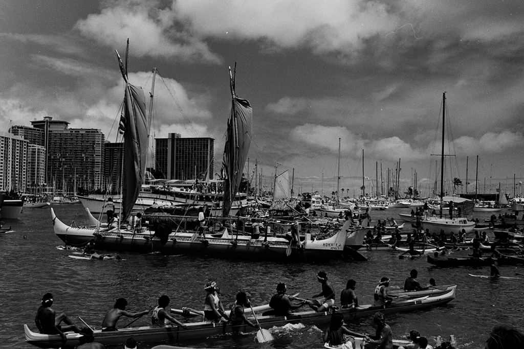
Hawai‘i received a category 5-size scare halfway through hurricane season this year. At its peak, on Aug. 22—the day the GOES-15 satellite captured this image—Hurricane Lane’s winds whipped up to 160 mph as it made its way toward the Islands. One day later, the system rapidly fell apart, from a major hurricane to a tropical storm in 24 hours, thanks in part to a meteorological phenomenon called wind shear that scientists say may not protect us much longer. Photo: NOAA
It’s never easy to assess a near thing that just missed being a worst-ever thing. Indeed, Hurricane Lane was such a letdown on O‘ahu after such a dire buildup that many were left exhausted and confused. Did we really just dodge a Katrina-level event that would’ve left O‘ahu with damage in the $25 billion to $50 billion range?
That’s what University of Hawai‘i civil engineering professor Amarjit Singh wrote in a newspaper column two days after the former Category 5 cyclone went from a Category 4 to a tropical storm in 24 hours while churning 150 miles off Waikīkī. What are our chances of it happening again—only, this time, making landfall?
It’s an interesting question. Tropical Pacific cyclones start forming every May at a point between Mexico’s Gulf of Tehuantepec and Baja California. If we think of cyclones as bowling balls and the eight Hawaiian Islands as pins, the Great Bowler of Tehuantepec throws many that don’t even make it to the two-thirds mark. Most that do end up gutterballs on the left or southern side of the lane, missing the Islands completely. But every year an average of four to five make it into striking range as full-blown hurricanes; of those a few veer north or northwest and affect us, usually as tropical storms. Only two hurricanes are considered to have made a direct Hawaiian landfall: Category 1 Dot hit Kaua‘i in August 1959 and Category 4 ‘Iniki did the same in September 1992. Category 1 Hiki in August 1950 and Category 1 ‘Iwa in November 1982 both barely missed Kaua‘i and caused great damage there, as well as on other islands.
SEE ALSO: How Do Hurricanes Get Their Names?
According to the National Hurricane Center, cyclone storm-surge damage on O‘ahu will be worst in low-lying areas such as Waikīkī.
From the record then, O‘ahu would seem to have little to fear. And in certain respects Lane was a successful validation of two well-known meteorological phenomena: Our hurricanes are generally weakened by colder waters north of 20 degrees latitude (which crosses the northern Big Island on a line running through Waimea) and are then torn apart by strong wind shear.
The latter is a feature of the semipermanent North Pacific High—an anticyclone that tears into hurricanes the moment they weaken. State climatologist Pao-Shin Chu, UH professor of meteorology, says, “it was amazing to see the vertical wind shear become strong and suddenly see Lane downgraded to a tropical storm and see the flow steer it away from the island. I said to my wife, we should celebrate.”

A track of Hurricane Lane shows how it intensified to a Category 5 on Aug. 22 when it crossed super-heated ocean water. Photo: NOAA
Colleague Steven Businger, professor and chair of the UH department of atmospheric science, felt certain that the double whammy would stop Lane. “That was the challenge for me—not if but when would the wind shear take the top off [the hurricane] and cause the leftward turn.”
But even he was impressed by Lane, the first Category 5 hurricane to come so close to Hawai‘i. “Lane had an unusual track,” he says, “coming straight north, showing landfall on Maui and O‘ahu. I hadn’t seen that before.”
Some storm veterans were frankly nervous. “I was a forecaster for 12 years, and I tend to discount hurricanes more than others,” says John Bravender of the National Oceanic and Atmospheric Administration, who is now the warning coordination meteorologist for Honolulu and the Central Pacific. “I took a hurricane hunter flight into Lane, right into a Category 4. When I landed and looked at my phone, that was the point that it all came together. Everything was trending. It could be a very serious thing.”
“We are very, very vulnerable. In 2015 we had three Category 4 hurricanes together at the same time in the Central Pacific.” — Pao-shin Chu, state climatologist
Though O‘ahu dodged a bullet, any celebration is bound to be short-lived. That’s because 2018 was not supposed to be an El Niño year, when ocean temperatures rise about a half a degree above the statistical mean, spawning more hurricanes. But a Category 5 has already been recorded this year and, says Businger, “There’s a swath of warm water and warm temperatures over the Pacific—two to three degrees higher than average. It’s an anomaly.”
Chu says the ocean temperatures have led NOAA to revise its forecast. “El Niño usually starts to develop in early summer so it is already three to four months late,” he said in mid-September. “Since El Niño is not fully developed now, the wind shear can still be large”—and its intervention with Lane was, he says, “not unusual.”
But as El Niño moves into November and even December, wind shear will weaken. And hurricanes have a way of coming late in the year. If wind shear does go away in late 2018 and lasts through next hurricane season, says Chu, “we are very, very vulnerable. In 2015 we had three Category 4 hurricanes together at the same time in the Central Pacific. Fortunately, none of them made an impact. But it was very scary.”
The near misses do damage, too, because of human behavior—the tendency to think the worst is over. “You’ve gone to the grocery store, you’ve stood on line, you’ve bought the tie-ons and straps,” says Bravender. “Don’t return the food or generators or batteries. Keep that level of preparedness.”
The way things are going, climate change could make preppers of us all. “This year’s ocean temperatures are warmer than last year,” says Chu, “and last year’s were warmer than the year before.” No matter what happens this year, “ocean warming will help hurricanes move northward.”
SEE ALSO: What You Need to Know About the 5 Hurricane Category Rankings

A view of hurricane lane from space shows the extent of its cloud band, carrying huge amounts of moisture from an El Niño-heated ocean. Photo: NOAA
With our first line of defense, cold ocean temperatures, retreating ever closer to O‘ahu, the second line, wind shear, becomes even more crucial. “In the end it’s the wind shear that protects us,” says Businger—and El Niño will lower those gates.
Long term, Businger adds, by 2075 climate change is expected to generate two more hurricanes a year on average. That doesn’t sound like a lot. But when you consider 2015 had 16 named storms in our region, the odds of a strike are only getting better. “We’re seeing more close approaches,” he says. “The time frame is shrinking for these 20-year events.”
Says Chu: “We need to invest more in hurricane research. Research to help the power companies, utilities, building codes, insurance—it’s all related. It will pay off, so maybe next time we will be better prepared.”